Understanding the natural world requires detailed knowledge of how landscapes, ecosystems, and terrain features interact. Environmental researchers rely on spatial data to study flood risks, monitor land use changes, and analyze forest ecosystems. However, collecting accurate information across large landscapes has traditionally been difficult and time-consuming.
A LiDAR scanner has changed how large-scale environmental data is gathered. By using laser pulses to measure distances to surrounding surfaces, the technology can generate detailed three-dimensional representations of landscapes. These digital models help scientists better understand terrain structure, vegetation patterns, and environmental change, making them valuable tools for modern environmental modeling.
Why Large-Scale Spatial Data Matters in Environmental Modeling
Environmental models depend on accurate spatial data to simulate how natural systems behave. Climate studies, watershed analysis, and ecological monitoring require precise representations of terrain and vegetation. Without reliable spatial information, predictions about environmental processes become less accurate.
Researchers often face several challenges when collecting spatial information across large landscapes:
- Limited coverage when using traditional surveying methods
- Difficulty measuring complex terrain or dense vegetation
- Time and labor required to survey wide geographic areas
A LiDAR scanner helps address these challenges by rapidly capturing millions of spatial measurements that represent terrain and vegetation in three dimensions.
How a LiDAR Scanner Works
At its core, a LiDAR scanner measures distance using laser light. The name “LiDAR” stands for Light Detection and Ranging, a remote sensing method widely used in geospatial mapping.
Laser Pulse and Time-of-Flight Measurement
A LiDAR device sends thousands, or even millions, of laser pulses per second toward surrounding surfaces.
Each pulse travels through the air, reflects off an object, and returns to the sensor. The scanner calculates distance using time-of-flight measurement, which determines how long it took the laser signal to return.
The basic process includes:
- Emitting a laser pulse toward a surface
- Detecting the reflected signal
- Calculating distance based on travel time
Because light travels at a known speed, this calculation produces highly precise distance measurements.
Creating 3D Point Clouds
Each laser return becomes a data point with spatial coordinates. When millions of these points are collected together, they form a structure known as a point cloud.
Point clouds represent the geometry of real-world surfaces in three dimensions.
These datasets can include:
- Ground terrain
- Trees and vegetation layers
- Rivers and waterways
- Buildings and infrastructure
Researchers can then process point clouds to generate digital terrain models, vegetation maps, or full landscape simulations.
Key Components of a LiDAR Scanner
Several integrated components allow a LiDAR system to capture accurate spatial measurements in the field. Each component plays a specific role in collecting and organizing environmental data.
Laser Sensor
The laser sensor is responsible for emitting pulses and detecting returning signals. Its performance determines how far the scanner can measure and how precise the distance calculations are. High pulse rates allow the scanner to collect dense spatial datasets that reveal detailed landscape features.
Imaging Systems
Many scanning systems include cameras that capture visual imagery alongside spatial measurements. These images can be applied to the point cloud to produce colorized 3D models of landscapes. This visual context helps researchers interpret environmental features more easily.
Positioning and Orientation Systems
Accurate positioning is essential when mapping large environments. LiDAR systems often integrate navigation technologies that track the scanner’s geographic location and orientation while scanning.
Common positioning components include:
- Global positioning systems for geographic coordinates
- Inertial measurement units that record motion and orientation
- Sensors that track movement through space during scanning
These systems ensure that the collected data aligns correctly with geographic mapping tools.
Onboard Processing and Storage
Scanning large areas generates substantial amounts of data. Modern scanning systems therefore include onboard processors and storage devices that record measurements during fieldwork. This allows researchers to collect extensive datasets without interrupting the scanning process.
Field Workflow: Capturing Environmental Data
The process of collecting spatial data typically follows a structured workflow.
Step 1: Survey Planning
Before scanning begins, researchers determine:
- Coverage area
- Scanning method (ground, vehicle, or aerial)
- Required data resolution
Step 2: Field Data Collection
Operators move the LiDAR scanner across the landscape or mount it on platforms such as vehicles or drones.
Common configurations include:
- Handheld scanning for forest plots and ecological research
- Vehicle-mounted systems for road corridors or riverbanks
- Drone-based surveys for remote or inaccessible terrain
Step 3: Real-Time Monitoring
Many systems provide live visual feedback, allowing operators to see scanned areas during capture. This helps prevent gaps in coverage and ensures the dataset is complete.
Step 4: Data Transfer and Processing
After scanning, the raw data is transferred to processing software.
This stage includes:
- Aligning multiple scans
- Removing noise or outliers
- Generating unified point cloud datasets
From Point Clouds to Environmental Models
Once point clouds are generated, they can be converted into a variety of environmental models used for scientific analysis. These models transform raw spatial measurements into structured representations of landscapes and ecosystems.
Terrain and Topography Modeling
One common application of LiDAR data is the creation of digital elevation models. These models represent the height and shape of the land surface and are used extensively in hydrology and geological studies.
Digital terrain models support applications such as:
- Flood risk assessment
- Watershed and drainage analysis
- Landslide and erosion monitoring
Accurate elevation data helps scientists understand how water flows across landscapes and how terrain influences environmental processes.
Vegetation and Forest Analysis
LiDAR technology is particularly useful for studying forests and vegetation structure. Laser pulses can pass through small gaps in tree canopies, allowing the scanner to capture data from multiple layers of vegetation.
Researchers use this data to measure:
- Tree height and canopy structure
- Forest density and biomass distribution
- Habitat conditions for wildlife
These measurements provide valuable insights into ecosystem health and long-term environmental change.
Digital Landscape Models
Environmental planners often use LiDAR data to build digital twins of natural environments.
These digital landscapes allow scientists to simulate:
- Climate effects on terrain
- Habitat changes over time
- Infrastructure impacts on ecosystems
Advantages of LiDAR Scanning for Environmental Studies
LiDAR scanning offers several advantages for environmental research because it can capture accurate spatial data across large landscapes quickly and efficiently.
Key benefits include:
- High spatial accuracy, often within centimeters
- Rapid data collection for large areas
- Ability to capture complex terrain such as forests and wetlands
- Repeatable surveys for long-term environmental monitoring
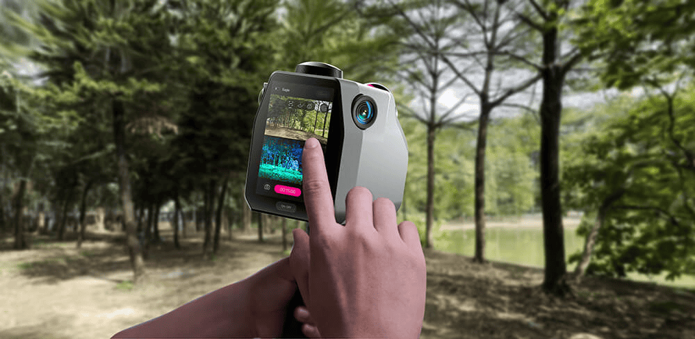
Some modern systems are designed to support these capabilities. For example, the 3DMakerPro Eagle LiDAR scanner features 8K Ultra Imaging, up to 140m scan range, up to 2cm accuracy, and an all-in-one workflow that supports efficient large-scale spatial data capture.
Conclusion
Environmental modeling relies on accurate spatial data that captures the complexity of real landscapes. A LiDAR scanner enables this by using laser pulses to measure distances across terrain, vegetation, and natural structures, producing detailed three-dimensional datasets of the environment.
These datasets, known as point clouds, allow researchers to generate digital elevation models, analyze vegetation structure, and study environmental changes. As environmental challenges continue to grow, LiDAR scanning technology provides an efficient and reliable way to map landscapes and support scientific research across large geographic areas.